
Page 29 - hisdeSAT annual report 2013
P. 29
29
represents a great advance in this field.
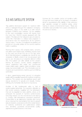
GLOBAL MARITIME TRAFFIC THROUGH AIS DATA
and, ultimately, guarantee environmental quality,
of maritime, continental and subterranean waters
natural disasters, avoid and control the contamination
at our disposal the mechanisms that help to prevent
Conservation is an inalienable objective and having
to comply with international protection protocols.
favouring respect for the environment and helping
anticipate the spread of maritime contamination,
that can be supplied by radar satellite, allows us to
AIS control systems, together with the information
environmental protection. The precision afforded by
Another of the fundamental roles is that of
fulfilling a humanitarian role of prime importance.
rescue operations for people and vessels, thereby
systems. This system can also facilitate search and
reality with the satellite-based AIS maritime monitoring
In short, guaranteeing ocean security is a tangible
authorities.
of great use to government, maritime, port and fishing
areas, fuel consumption, etc. This information can be
made, draft, length, registry, wave conditions, rocky
status, destination and cargo, any manoeuvres
identity, its location, course, speed, navigational
AIS. The system can offer details on the vessel’s
put to use. Accuracy is an essential element of the
computer on Earth, where it can be processed and
All of this information is available via internet to any
to the coast and those that are on the high seas.
and other route-related data, identifying vessels close
Working from space, AIS compiles static, dynamic
traffic in real time.
provide an accurate picture of the world’s maritime
various users. This new constellation of satellites will
accordance with the requirements of the system’s
where the information is collated and prepared in
system. The data are then relayed to ground stations,
the more than 100,000 vessels equipped with this
in this new constellation receive AIS signals from
between COMDEV and Hisdesat. The ten satellites
exactEarth, which is the result of a joint venture
the service of society.
innovative uses provided from space and placed at
(AIS) is managed through the Canadian Company,
helping to reduce environmental impact. These are
The satellite information system for maritime traffic
and palpable concept of maritime safety, whilst
aimed at guaranteeing the viability of the extensive
through AIS have made up for the dearth of solutions
3.3 AIS SATELLITE SYSTEM
Systems for the satellite control of maritime traffic