
Page 17 - hisdeSAT annual report 2010
P. 17
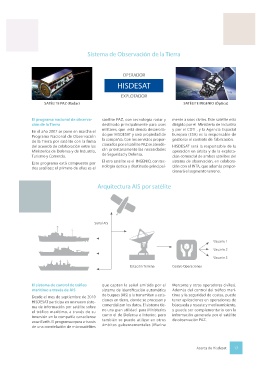
At international level secure commu-  The National Earth Observation   The other satellite is INGENIO, which   Sistema de Observación de la Tierra
 nications service is provided to the US   Program   uses optic technology and is mainly
 Department of Defense, the Belgian   In 2007 a Collaboration Agreement   meant for civilian purposes. It is run
 and Norwegian defense ministries   was signed by Spain’s Ministries of   by the Ministry of Industry and by the
 and the Danish Navy, and via the hol-  Defense and of Industry, Trade and   CDTI (Center for the Development of   OPERADOR
 ding Xtar LLC to the US Department   Tourism to move forward with the   Industrial Technology), while the Eu-
 of State and various US government   National Satellite Earth Observation   ropean Space Agency (ESA) oversees   HISDESAT
 bodies.  the contract to build it.
 Program.
 HISDESAT is currently in the initial   The program comprises two satellites.   HISDESAT will assume responsibility   EXPLOTADOR
 development phase of HISNORSAT, a   PAZ is a radar satellite meant mainly   for orbital operations and commer-  SATÉLITE PAZ (Radar)  SATÉLITE INGENIO (Óptico)
 new communications satellite to be   for military uses; it is being developed   cial exploitation of both observation
 managed jointly with the Norwegian   by HISDESAT and will be owned by   system satellites, in cooperation with
 Defense Ministry. This satellite will be   the company. Services provided by   INTA, which will also provide the   El programa nacional de observa-  satélite PAZ, con tecnología radar y   mente a usos civiles. Este satélite está
 placed in a Spanish orbital position   the PAZ satellite will primarily address   ground segment.  ción de la Tierra  destinado principalmente para usos   dirigido por el  Ministerio de Industria
 with coverage from the Atlantic to   security and defense needs.   The system for controlling mariti-  En el año 2007 se pone en marcha el   militares, que  está siendo desarrolla-  y por el CDTI , y la Agencia Espacial
 South East Asia. It will count 40 trans-  me traffic via AIS  Programa Nacional de Observación   do por HISDESAT y será propiedad de   Europea (ESA) es la responsable de
 ponders active in the government X   de la Tierra por satélite con la firma   la compañía. Con los servicios propor-  gestionar el contrato de  fabricación.
 and military Ka frequency bands, and   Since September 2010 HISDESAT has   del acuerdo de colaboración entre los   cionados por el satélite PAZ se atende-  HISDESAT será la responsable de la
 complement the secure communica-  taken part in a new maritime traffic   Ministerios de Defensa y de Industria,   rán prioritariamente las necesidades   operación en órbita y de la explota-
 tions system now operational.  satellite information system via its   Turismo y Comercio.   de Seguridad y Defensa.   ción comercial de ambos satélites del
 investment in the canadian company   Este programa está compuesto por   El otro satélite es el  INGENIO, con tec-  sistema de observación, en colabora-
 exactEarth. The program operates   dos satélites; el primero de ellos es el   nología óptica y destinado principal-  ción con el INTA, que además propor-
 via a network of microsatellites that                                        cionará el segmento terreno.
 capture signal sent by the automatic
 identification system for vessels (AIS)
 and transmits it to ground stations,       Arquitectura AIS por satélite
 where the information is processed
 and commercialized. The system
 is very useful for ministries such as
 Defense and Interior, but can also be
 used in non-governmental situations
 (Merchant Marine and other civilian
 operators). Besides controlling ma-       Señal AIS
 ritime traffic and coastal security, it
 can be used in search and rescue and
 environmental operations. It can also                                                          Usuario 1
 complement information generated
 by the PAZ observation satellite.                                                              Usuario 2
                                                                                                Usuario 3
                                                           Estación Terrena   Centro Operaciones


               El sistema de control de tráfico   que captan la señal emitida por el   Mercante y otros operadores civiles).
               marítimo a través de AIS       sistema de identificación automática   Además del control del tráfico marí-
                                              de buques (AIS) y la transmiten a esta-  timo y la seguridad de costas, puede
               Desde el mes de septiembre de 2010
               HISDESAT participa en un nuevo siste-  ciones en tierra, donde se procesan y   tener aplicaciones en operaciones de
 Información de tráfico marítimo obtenida a través del sistema AIS.  ma de información por satélite sobre   comercializan los datos. El sistema tie-  búsqueda y rescate y medioambiente,
                                              ne una gran utilidad  para Ministerios
                                                                              y puede ser complementario con la
               el tráfico marítimo, a través de su
               inversión en la compañía canadiense   como el de Defensa e Interior, pero   información generada por el satélite
               exactEarth. El programa opera a través   también se puede utilizar en otros   de observación PAZ.
               de una constelación de microsatélites   ámbitos gubernamentales (Marina


 16  About Hisdesat                                                                     Acerca de Hisdesat  17