
Page 31 - hisdeSAT annual report 2011
P. 31
HIGHLIGHTS 2011
3.4 AIS satellite system
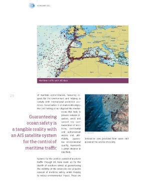
The satellite information system for maritime traffic (AIS)
is managed through the Canadian Company, exactEarth,
which is the result of a joint venture between COMDEV
and HISDESAT.
The ten satellites that form part of this new
Maritime traffic with AIS data
constellation receive AIS signals from the
more than 60.000 vessels which have this
system, delivering this data to the terres-
trial stations, where the information is col-
28 lated and prepared in accordance with the 29 of maritime contamination, favouring re-
requisites of the different users of this sys- spect for the environment and helping to
tem. This new constellation of satellites comply with international protection pro-
provides information on global maritime tocols. Conservation is an inalienable objec-
traffic in real time. tive and having at our disposal the mecha-
nisms that help to
This new Working from space, draft, length, flag, swell, rocky areas, en- Guaranteeing prevent natural di-
sasters, avoid and
AIS compiles stat-
constellation of ic, dynamic and ergy consumption, etc. This information is ocean safety is control the con-
very valuable for governmental, maritime,
other data relating
tamination of mar-
satellites provides to route, detect- port and fishing authorities. a tangible reality with itime, continental
ing boats that are and subterranean © CNES 2005
information on global close to the coast In short, guaranteeing ocean safety is a an AIS satellite system waters and, ulti-
and those which tangible reality with satellite system for the mately, guaran- innovative uses provided from space and
maritime traffic in real are sailing in open control of maritime traffic, AIS. This system for the control of tee environmental placed at the service of society.
ocean, with all this can also facilitate search and rescue oper- quality, represents
time information arriving ations for people and vessels, thereby ful- maritime traffic a great advance in
via Internet to any filling a humanitarian role of primordial this field.
computer on Earth, importance.
for its subsequent processing and use. Pre- Systems for the satellite control of maritime
cision has become an indispensable ele- Another fundamental role is that of envi- traffic through AIS have made up for the
ment of AIS, by being able to provide details ronmental protection. The precision afford- dearth of solutions aimed at guaranteeing
on the identity of the vessel, its location, ed by AIS control systems together with the the viability of the extensive and palpable
route, speed, navigation status, destination information that can be supplied by radar concept of maritime safety, whilst helping
and freight, the manoeuvres it performs, satellite, allows us to anticipate the spread to reduce environmental impact. These are