
Page 23 - memoria_hisdesat_2020
P. 23
La inteligencia aportada por dichas imágenes es cla- Gracias a estos servicios de valor añadido implemen-
ve en la planificación de las misiones, la estrategia de tados por Hisdesat -y también por sus propios clientes
despliegues y en la toma de decisiones de los mandos con autonomía para extraer información de las imáge-
militares, así como en las operaciones de organizacio- nes PAZ- se contribuye a avanzar en la consecución de
nes civiles para la gestión de actuaciones. los Objetivos de Desarrollo Sostenible (ODS), intentan-
do siempre mejorar nuestro entorno. Los productos
Los productos resultantes de derivados de los servi- derivados podrían ayudar de forma fiable a la toma
cios de valor añadido que ofrecen sus imágenes con- de decisiones para proteger nuestro medio ambiente
tienen información que puede ser relevante al usua- y la sociedad en general, apoyando así, al diseño de
rio en un momento dado sobre su zona de interés. estrategias y medidas de adaptación y resiliencia para
el clima y la sostenibilidad.
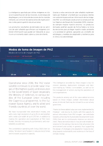
Modos de toma de imagen de PAZ
Modos de toma de imagen de PAZ
Operational since 2018, the PAZ radar The intelligence provided by these images is key for
satellite continues to provide radar ima- mission planning, deployment strategies and deci-
ges of the highest quality and resolution sion-making by military commanders, as well as for
the management of actions during the operations of
to the Government of Spain (especially civil organizations.
the Ministry of Defence), to various bo-
dies of the European Union including The products arising out of the value-added services
the Copernicus programme, to the Eu- based on these images contain information about
ropean Space Agency, and to allied and areas of interest that may be relevant to a user at any
given time.
friendly countries all over the world.
Thanks to these added value services implemented by
We have incorporated new observation modes, one Hisdesat – and also by its clients with the capacity to
with a very high resolution of up to 25 cm and another extract information from PAZ images – we contribute
with a wide scan width of up to 270 km, in addition to towards achieving the Sustainable Development Goals
making the operation and exploitation of PAZ more (SDG) that aim to continuously improve our environ-
flexible, thereby increasing its performance and mar- ment. These derived products may provide reliable as-
ketability as planned. sistance for the taking of decisions that will protect the
environment and society in general, thus supporting
The constellation operating with Airbus D&S’s twin sa- the design of strategies and adaptation measures lea-
tellites, TerraSar-X and Tandem X, reduces revisit times ding towards sustainability and resilience in the face of
and increases acquisition capacity. climate change.
ANNUAL REPORT 2020 | HISDESAT | 23