
Page 23 - hisdeSAT Informe Anual 2019
P. 23
23
MILESTONES
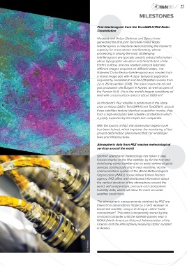
First Interferogram from the TerraSAR-X/PAZ Radar
Constellation
Hisdesat and Airbus Defence and Space have
generated the first joint TerraSAR-X/PAZ Radar
Interferogram, a milestone demonstrating the mission's
capacity for cross-sensor interferometry whose
processing is among the most challenging.
Interferograms are typically used to extract information
about topographic elevation and deformation of the
Earth's surface, and are created using at least two
different images acquired on different dates. The
flattened Cross-Sensor-Interferogram was created from
a mixed image pair with 4 days’ temporal separation
acquired by TerraSAR-X and PAZ (StripMap scenes from
22 to 26 November 2018). The area covers the oil and
gas production site Burgan in Kuwait, as well as parts of
the Persian Gulf. This is the world’s largest sandstone oil
field with a total surface area of about 1,000 km².
As Hisdesat’s PAZ satellite is positioned in the same
orbit as Airbus D&S’s TerraSAR-X and TanDEM-X, and all
three satellites feature identical acquisition modes, they
form a high-resolution SAR satellite constellation which
is jointly exploited by the respective companies.
With the launch of PAZ, the observation repeat cycle
has been halved, which improves the monitoring of fast
ground deformation phenomena that can endanger
lives and infrastructures.
Atmospheric data from PAZ reaches meteorological
services around the world
Spanish operational meteorology has taken a step
forward thanks to the PAZ satellite, by for the first time
distributing useful satellite data to world meteorological
services continuously and in near real time, via the
communications system of the World Meteorological
Organization (WMO), a specialised United Nations
agency. PAZ offers well-distributed information about
the vertical structure of the atmosphere around the
world, with temperature, pressure and atmospheric
humidity data, which will allow for more accurate
weather predictions.
The atmospheric measurements obtained by PAZ are
taken from observations made by a GPS receiver on
board the satellite, using a technique called “radio
concealment”. This data is temporarily stored by the
on-board computer until the satellite passes near a
NOAA (North American National Administration of the
Oceans and the Atmosphere) receiving station located
in Alaska.
© Hisdesat